
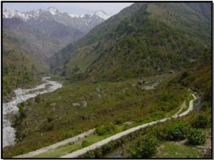
The Himalayas, an integral part of the Indian heritage and its forests provide vegetative cover for the major river systems in India, serve as water reservoir, and are a warehouse of biodiversity, and a climate maker for the whole of Asia. Uttarakhand is the catchments area of the Indo-Gangetic plain and the cradle of the Indo-Gangetic civilization. Uttarakhand is divided into two commissionaires’, Kumaon and Garhwal. Kumaon lies between 28°44’ and 30°49 N latitudes and 78°45 and 81°5 E longitudes.
Water management
The main sources of water in Kumaon are rainwater, glaciers, rivers, lakes, streams (of all sizes) and springs. Kumaon region lies in the monsoon belt and thee communities in this region learned to collect rainwater, store it and use it for a variety of purposes throughout the year. Thus, a unique water harvesting civilization took shape in this region. In the pre-colonial period although the state was not responsible for providing water to its citizen; it had no intervention in the various uses of water by its people. There was community management of water for irrigation and drinking as per the need of the people. Traditional water management took birth from this system. The local communities had the right of ownership over the use of local natural resources and the state recognized this right.
Water was revered and regarded as sacred. Since, the water bodies were considered to be sacred, they were well maintained. It was so sanctified that river or Pani Dhara marriage, which was publically performed in a sacred place in a river or spring, was given due recognition by the society. Both the river or Pani Dhara and the Kumbh Vivah were given legal recognition. In the former, the nuptial ceremony was solemnized in the presence of a water body. According to Kumbh Vivah, when the bridegroom was inevitable absent the bride was formally married to a pitcher of water representing him. Traditionally in Kumaon, the main systems of water harvesting are guls, naulas, dharas, lakes, kund, khal, simar or gazar and water mills. Many of these technologies are still in use and provide a significant proportion of the water requirements of the people. The traditional systems are being detailed below:
Gul
In Kumaon, cultivation is done largely on terraced fields and since ancient times, the problem of irrigating the fields was resolved by diverting water from nearby streams or rivers through channels called guls. They are the best example of water resource management in the hills and are usually dug along the contours of the slope. Apart from irrigation, guls were used for drinking water and for running gharats or water mills.
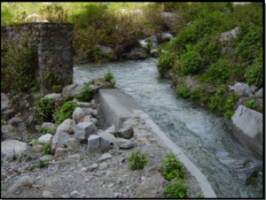
In some areas, water from the stream is first dammed and then the irrigation channel is made. The small dam constructed for the purpose is known as baan in local parlance and kulayana in Kumaoni dialect, which means to irrigate the field with gul or kul. Along the length of the guls are outlets, which lead to small secondary channels, known as hawarr. Irrigation channels are of various sizes, the one, which is smaller than kul is known as baul.
A boulder is placed at the outlet controls flow of water. There is also an outlet at the lower end of the field, which allows the excess water to flow on to the lower terraces from where it ultimately drains back to the stream. Sometimes, the flow water in the gul is obstructed by a boulder or hard rock. In that case, the peeled bark of a banana tree is used as a water carrier or it is channelized through a wooden pipe.
Naula
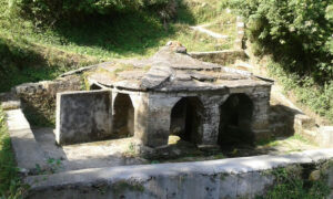
Naula are designed to collect water from subterranean springs. The flow of these springs is very sensitive and can be disturbed by seismic activity and human disturbance. In Dwarahat, during survey it was found that several naulas like Khulkuda or Kholibhitar have dried up owing to the tremors of earthquake. Naulas mostly found on the hill slopes in the lesser Himalayan region of Kumaon are covered reservoirs and exhibit masterpiece architectural features. Some of the naulas like the Ek-hatia Naula and Baleshwar Naula in district Champawat are famous for their architectural splendours.

The naulas have a common design. They consist of a tank that is closed on three sides and covered. The fourth side, which is open, has steps that lead down to the tank. There is a pillared verandah around them with engravings. Animals are not permitted to enter and the system is so designed that the users do not contaminate the source. All the water is considered sacred, even to this day the basic rules of sanitation and hygiene are mostly observed.
Naulas were considered community property and the villagers revered their naulas. In the past, naula water was treated with amla (Emblica officinalis Gaertn) and neem (Azadirachta indica A Juss) leaves. As the construction of naulas was considered prestigious, these structures can be found in ancient towns, in and outside villages and on important roads. Some naullas are emblazoned with intricate architectural designs. At times they are massive in size with a raised platform for both bathing and washing.
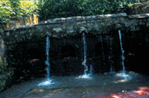
Dhara

It is a common source of drinking water and can be compared with a drinking water fountain. Dharas located both in mountain crests and in valleys are also popular in townships. In Nainital itself, Parda Dhara and Siphai Dhara are used as public baths and people collect drinking water from Chuna Dhara, Tunestein Hall Dhara, Hanuman Garhi road Dhara, Motapani Dhara and Gufamahadeo Dhara, etc.

In dharas also, the practice of planting trees was in vogue for symbolizing the sanctity of water. The water from a spring or a subterranean source is channeled through carved outlets. They are often in the shape of a pipe, through figures of animals like lions and cows also in vogue.
There are 3 types of dharas depending upon their heights and nature of flow. If an individual can easily drink water from the dhara in a standing position, then it is called Sirpatia Dhara; if one has to bend over for drinking water, then it is called Murpatia Dhara (Murpatya means bending up to knee level). Both these types of dharas are decorated with animal figures. The third type of dhara is not perennial in nature. During the rainy season, some wooden spouts or broad leaves are stuck in the path of a flowing stream or a spring that gets recharged during that period. As they are temporary in nature, they are called Patveedia Dhara (Patveedia means ephemeral).
Simar
Simar are also known as gajar. Gajar is a marshy tract of land in an agricultural field and is created by the ground water. It is aptly suited for paddy cultivation. Cultivation of high quality crops like basmati rice, medicinal plants and herbs are a common feature in Gajars. The medicinal plants normally grown in it are two varieties of brahmi (Centella asiatica (L) Urban) and (Bacopa monnieri (Linn.) penn)
Chuptaula
These are basically water holes for animals and are found mostly in high altitudes for use of graziers. They are not permanent in nature and water is collected in them from springs or from points where water oozes out from the ground. Faunal and bird life also use this accumulated water and at times they serve as an important source of water for human consumption at high altitudes.
Khal

Large depressions in mountainous areas used for rainwater harvesting are called khals (Fig. 16). Mostly they are on top of ridges in the saddle between two crests. At times small ponds are also dug for collecting rainwater. During the lean period, water accumulated in khals is used for irrigation purposes. When discharge of water in guls is reduced owing to the searing heat of summers, then water is accumulated first in a khal and subsequently used for irrigation.
Dhaan
Water collected from small and big streams gives the shape of a lake. The accumulated water is used for bathing of domestic animals and irrigation. The traditional system of water management was similar in the hilly terrain of Garhwal and Himanchal Pradesh.
Deforestation and urban conglomeration have led to drying up of water sources. In Dwarahat township in Almora district there were about 360 naulas in the 1900s, but now about 36 naulas have a perennial supply of water. Rampant deforestation and unnecessary road construction in the catchments area together with faulty planning has led to this crisis. Again in the last two decades in the catchments area of the river Gaula in Nainital district, almost 46% of the springs have dried up and almost 60% have become seasonal. According to a recent report, 121 natural springs have dried up and in 850, the capacity has dwindled by 50%. In Kumaon, 55% of the systems constructed for drinking water are functional while 45% are non-functional. It is essential that all agencies related to water resources, should have an integrated approach both in theory & practice and the planning should be done with the help of villagers.
Source:
http://nopr.niscair.res.in/handle/123456789/3942
http://hindi.indiawaterportal.org/Nainital-Lake